

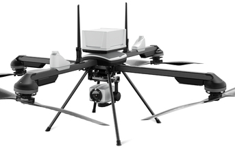
ideaForge Technology Limited, a leading global drone technology company, today announced its partnership with Inertial Labs, a global leader in innovative inertial sensors and integrated GPS systems, for the integration of Inertial Labs' RESEPI LiDAR solution into ideaForge's high-performance unmanned aerial vehicles (UAVs). This collaboration represents a significant advancement in UAV-based LiDAR mapping, offering industries an enhanced, highly accurate, and reliable solution.
Increasingly customers are realising the need for LiDAR based drones for aerial data collection and precise 3D mapping capabilities across surveying, mapping, mining, construction, forestry, power line inspection and search and rescue.
LiDAR technology has immense potential in India's varied landscapes, with new applications emerging constantly. As part of the partnership, ideaForge and Inertial Labs will jointly work together to provide surveying, mapping and inspection solutions across specific applications in mining, forestry, GIS and land surveys, water resources management, among others. The seamless integration of Inertial Labs' precise LiDAR payloads with ideaForge's advanced NETRA/Q6 class of UAVs will help in delivering aerial data with extreme precision, speed and actionability insights.
Ezhilan Nanmaran, Head of Product and Strategic Partnerships at ideaForge Technology Limited said, "Our collaboration with Inertial Labs signifies a major leap forward in our UAV-based LiDAR mapping capabilities. This advancement enables us to achieve unparalleled precision and efficiency in data collection, revolutionising mapping practices across agriculture, infrastructure, and environmental monitoring sectors. We are dedicated to driving innovation and offering our customers state-of-the-art solutions that expand the horizons of UAV-based LiDAR technology."
The integration of Inertial Labs' RESEPI LiDAR solution with ideaForge's UAVs, particularly the NETRA/Q6 class, ensures users receive highly accurate and reliable data for their mapping and surveying needs. This advanced technology maintains high accuracy and point density at recommended flight altitudes, making it essential for various applications. In LiDAR mining assessments, it offers precision for stockpile volume calculations, slope stability analysis, and environmental impact assessments. For long-range surveying, it enables high-density mapping with extended flight times and lightweight design. Additionally, in utility infrastructure management, the high point cloud density and precision, which allow the system to capture the smallest details, including the powerlines of transmission towers.
"We are excited to partner with ideaForge, highlighting our commitment to industry advancement. In today's fast-paced tech landscape, staying ahead is crucial. This collaboration combines our innovative technologies to deliver top-tier accuracy and reliability empowering users across diverse sectors," said Jamie Marraccini, CEO at Inertial Labs.
The integration of LiDAR based solutions into ideaForge's UAVs is an essential component towards building capabilities in surveying and mapping solutions. These UAVs will be equipped with a variety of autonomous capabilities, including autonomous flight to predefined waypoints, automatic takeoff and landing, obstacle avoidance, fail-safe return to home, and the ability to fly at negative altitudes.